
INTERREG III B CADSES
project part-financed by the European Union
|
INTERREG III B CADSES project part-financed by the European Union |
PlanCoast project duration was April 2006 – April 2008
What was PlanCoast?PlanCoast was an INTERREG IIIB NP CADSES Project with the aim to develop the tools and capacities for an effective integrated planning in coastal zones and maritime areas in the Baltic, Adriatic and Black Sea regions.
PlanCoast had 16 partners representing the spatial planning departments or responsible regional authorities from Albania, Bosnia–Herzegovina, Bulgaria, Croatia, Germany, Italy, Montenegro, Poland, Romania, Slovenia and Ukraine. Read more 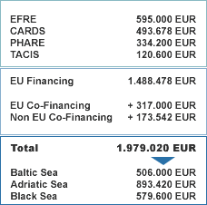 PlanCoast Data Duration 2006-2008 NEWSNo News. |
|---|
